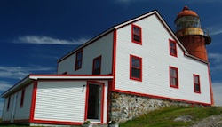
At the second most easterly point in North America the Lighthouse now serves gourmet picnics

Ferryland: What do you do when a lighthouse goes out of business, start up a new business: lighthouse picnics. Started 8 years ago by Jill Curron, a young Newfoundlander who had spent several years living travelling overseas, there are now 13 local residents on staff and up 100 or more people a day drop by for the spectacular view and picnic.
You find the perfect perch and they provide the blanket and basket, everything from Seafood Club to Curried Chicken sandwiches, plus dessert. Even the bread is baked on the site, including the favorite - oatmeal and molasses. And, there's homemade lemonade - the staff at the Lighthouse are the largest user of lemons in all of Newfoundland.
The lighthouse dates back to 1870. What you might see from your perch over the Atlantic – whales (late June they tend to start coming closer to shore) migratory birds, and occasionally even an iceberg might drift by.
Where: The Lighthouse is in Ferryland NFLD, that’s 80 km south of St. John’s, on the second most easterly point of North America. The walk in is about 2km or 25 minutes from the beginning of Lighhouse Road. Pinics are served from late May until late September (weather dependent.) Visit LighthousePinics.ca for information on reservations. In the Region: Cape Race is just 45 km away. It was the location that recevied the last transmission from the sinking Titantic (the 100th anniversary of that event will be in 2012). The most easterly point in North America is Cape Spear near St Johns. While driving in Newfoundland, watch for moose. There are about 125,000 in the province, decended from just four who arrived from New Brunswick in 1904. They can be a road hazzard, especially at dusk and dawn. An adult male averages 385 to 534 kilograms - that's 850 to 1180 lbs! |
Jill Cureen, owner of this lighthouse, iis now also president of Maxxim Vacations Photos courtesy of Lighthouse Picnics.
|

Lucy Izon
Canada Cool is produced by award-winning Canadian travel writer & speaker Lucy Izon. Her travel stories & reports have appeared in numerous leading North American publications including the Los Angeles Times, Chicago Tribune, Toronto Star, Globe and Mail, and Chicken Soup for the Traveler's Soul. Bio page
Canada’s Coolest:
Welcome to a new feature on Canada Cool. I'll be presenting different 'Coolest' lists with my favorites and I encourage you to nominate suggestions from your own experiences. You can Twitter @CanadaCool or email [email protected]. Let me know what makes your suggestion exceptionally cool. Remember, by contributing your comments you are giving Canada Cool permission to quote you. Only a selection of submissions will be included, but all comments and submissions are greatly appreciated!
The first feature is: Canada's Coolest Single Day Scenic Drives
Here are some of my favorites...

The Icefields Parkway, Jasper National Park, Alberta - This 229 km (142 mi) Rocky Mountain route from Banff/Lake Louise to Jasper passes 100 frozen rivers and nudges the base of the Athabasca Glacier - the most accessible glacier in the world. You can stop and explore it. It spills down from the Columbia Icefield, an area of ice so massive that you could fit the entire population of North America on it with each person getting at least a square metre of space.

The Corridor, Algonquin Park, Ontario – this 56-km stretch of Hwy 60 cuts through the southwest section of Algonquin Park. Less than three hours north of Toronto the park is a nature-lover's paradise with 7,725 km of lakes, rivers, forest, trails, camping, comfortable lodges and 2000 km of canoe routes. Offers hiking trails to stop and enjoy, but what makes it really cool is that it’s one of the best places in North America to spot moose (especially in May and June). And, on Thursday nights in August up to 600 cars will gather to listen to wolves howl.

The Cabot Trail, Cape Breton, Nova Scotia – Driving this 303 km (187 mile) route is like riding a roller-coaster: the road snakes around hairpin turns, rises to heights over 365 metres (1200 ft), weaves around headlands revealing spectacular coastal scenery, and plunges down to sea level taking you into the heart of small fishing communities. The most dramatic scenery is between the Cape Breton Highlands National Park entrance near Cheticamp and Pleasant Bay, so go slow. And, plan some flexibility into your schedule, so you can drive it on a clear day.
And here are some of your nominations for 'Canada's Coolest Single Day Scenic Drives'...
More from Canada’s Coolest
'Canada's Coolest' topics we'll be publishing in the future:
- Golf Course Features
- Haunted Hotels
- Hotel Special Services
Send your suggestions to [email protected]
Recent 'Canada's Coolest' topics:


